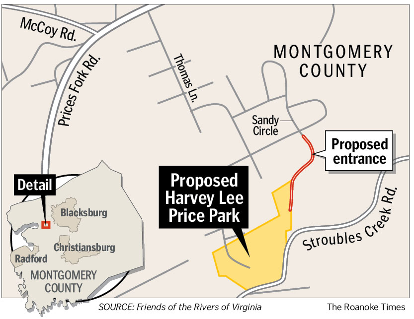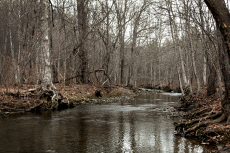
Photos by Matt Gentry | The Roanoke Times
Stroubles Creek flows Wednesday through the proposed 44-acre Harvey Lee Price Park in the Prices Fork area of Montgomery County.
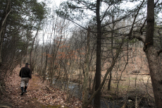
Photos by Matt Gentry | The Roanoke Times
Randi Lemmon, a Friends of the Rivers of Virginia board member, walks along an old woods road next to Walls Branch in the proposed Harvey Lee Price Park in Montgomery County on Wednesday.
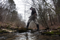
Photos by Matt Gentry | The Roanoke Times
The property was donated to Friends of the Rivers of Virginia with the condition that it be maintained as public land. Now the group is trying to convert it to a park.
| Related |
Map |
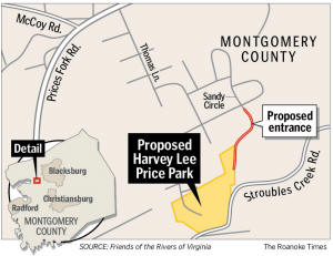 |
Source: Friends of the Rivers of Virginia |
| Click the image to see a larger graphic. |
PRICES FORK - The coal pits have largely vanished along the road that carried wagons to the Price family grist mill. There is no trace of the mill anymore, and the road itself is hard to spot in places, hidden beneath piles of fallen brush.
But the wooded mountainsides are little changed above Stroubles Creek. And tall grass and sycamores have not completely overtaken fields once farmed by Harvey Price, the longest-serving agriculture school dean in Virginia Tech history.
Price's granddaughter wants 44 acres of this land to become a public park for the community that bears her family's name. The Montgomery County Board of Supervisors will soon be asked again to accept the land as a donation, said two board members of the Friends of the Rivers of Virginia, a conservation group that now owns the property.
In August 2010, Anne Price Yates offered to give part of her grandfather's farm to the county for a park. Supervisors, who were in the midst of deciding to build new high schools in Blacksburg and Riner and to renovate Auburn Middle School, declined, saying they had no money to develop or maintain it.
Last December, Yates, who lives in Oregon, donated the property to the Friends of the Rivers of Virginia with the condition that it be maintained as public land. Now the rivers group is taking up Yates' effort to convert it to a park.
Bill Tanger, chairman of the rivers group's board, and Randi Lemmon, another board member, said this week that they have been contacting county officials to relay information about the proposal. They hope to make a formal presentation to supervisors this month.
The key, as they see it, is that the county won't have to spend much on the park.
"No one's asked for money," Lemmon said Monday. "This would be a donation."
Tanger and Lemmon compare the proposed Harvey Lee Price Park - Yates wrote the name into the transfer agreement - to the Whitt-Riverbend Park that both were involved in creating a decade ago in Giles County.
There, a coalition of conservation groups and a state grant helped the town of Pearisburg acquire the park. Grant funding and volunteer labor took care of most of the work on the 27-acre park, such as installing a paved trail and parking lot.
Part of the information packet that Lemmon and Tanger have assembled on the Prices Fork proposal is a Jan. 17 report from Pearisburg Town Manager Ken Vittum, who wrote that the town has spent no more than $23,000 on Whitt-Riverbend since obtaining it in 2001. Camping fees bring in about $1,750 per year to cover maintenance, Vittum said.
The proposed park in Montgomery County could buffer Stroubles Creek against development, including a long-planned, limited-access road to relieve congestion on Prices Fork Road by connecting Prices Fork more directly to the U.S. 460 Bypass around Blacksburg.
In another part of Tanger and Lemmon's information packet, former Virginia Department of Transportation Resident Engineer Dan Brugh, now executive director of the Blacksburg/Christiansburg/Montgomery Area Metropolitan Planning Organization, wrote that the new road to Prices Fork is to be accompanied by a parallel greenway that would fit well with park plans.
County sewer and water lines already follow Stroubles Creek across the property.
Lemmon and Tanger said there is some potential for ongoing income from the property via a lease to Virginia Tech, which owns adjoining land that now must be reached from Stroubles Creek Road. Extending an access from the proposed park entrance on Sandy Circle in the Montgomery Farm subdivision would make for a shorter transit time from campus.
Supervisor Bill Brown, whose district includes Prices Fork, predicted that county officials will give more consideration to the idea of establishing a park. "The board hasn't completely closed the door. They're open to listening to what they had to present," Brown said.
Brown said that one factor he would want to consider was the tax loss the county would sustain by taking the land from private ownership.
Lemmon said taxes on the property now are about $1,200, but will drop to a third of that or less after the rivers group completes a planned conservation easement on the property.
Supervisor Matt Gabriele, who was elected last fall, after the board considered and rejected Yates' offer, said he met with rivers group representatives in December and wants to know more details about how a park would work. "It seems like an interesting possibility but remains only that - a possibility - at least for now," he wrote in an e-mail Wednesday.
Supervisor Chris Tuck, also elected since the board's earlier consideration of the park, said that he generally supports the idea of the park. "This park could be a real asset to the county's long-term future plans," Tuck wrote in an e-mail Monday.
Tuck said his backing hinges on several issues, including that someone further research on the life of Harvey Price, who dug coal from his family's land to pay tuition and earned an undergraduate degree at Tech in 1898. He completed a master's degree in 1900, then joined the faculty. He was named dean of agriculture in 1908 and held the office until retiring at the start of 1946.
Price is described in an old Tech bulletin as noted hunter and fisherman as well as researcher, teacher and administrator. Tuck said it was only proper that the county should make sure there are no reasons that could complicate naming a park for him.
Tuck said he also wanted the Friends of the Rivers of Virginia to convey a right-of-way to enter the property and a spot for a parking area.
Lemmon and Tanger said the property will come with a 50-foot-wide path for an access from the end of Sandy Circle. At the other end of the property, Stroubles Creek Road might provide another entrance.
Lemmon said the rivers group will ask the county to accept the land and to establish a committee to begin making plans for parking and other work, and searching for ways to pay for it. He predicted the basic tasks - the driveway and parking, mowing some of the bottomland, perhaps a picnic shelter - would not be difficult to accomplish.
"It's amazing - money flows to good plans," Lemmon said.
In 2010, county staff determined it would take at least $9,000 or so to survey the property, perform an environmental study and title search, clean up debris and put up signs.
.pdf Printable Version